
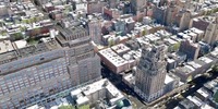
 We’ve been fascinated by a video of Google’s new feature for their popular Google Earth product: 3D imagery. You might be surprised to realize that the image above is NOT a photograph of New York City, but was from a new version of Google Earth that incorporates street view images and superimposes them on 3D building representations. The result, as you’ll see in the video below, is startling.
 This gave us an idea we’d like to pass on to Google. As everyone knows, Google already has the largest repository of 3D models through its Sketchup community and Google 3D Warehouse. But we’re thinking the repository idea could also apply to Google Earth.
Some of you may have used Google Earth to print useful 2D maps, but what if you could print 3D maps? In other words, specify a geographical area, hit print and select the “3D Option”, which would produce a .STL or other 3D format file suitable for printing, complete with textures? If that were so, 3D printers around the world could pump out tiny models of The Pyramids, Times Square, Venice and other notable places.
We wouldn’t be surprised if this is already possible through public data interfaces, but it would be a big step if Google added this feature directly into Google Earth.
Just watch out for that Google Street View car; if you see it whizzing by, you might end up in a 3D print somewhere.
Via YouTube