

 You may have guessed we’re fascinated with new ways of capturing 3D models for printing, and this week we’ve found a rather unusual method: UAV images. Researchers at Ecole Polytechnique Fédérale de Lausanne’s Computer Vision Laboratory have developed software to combine thousands of images gathered by UAVs into very usable 3D models.
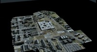
 The software, produced by spin-off company Pix4D, enables the creation of very detailed, large-scale 3D map models at very low cost. Images are loaded up to a cloud-based service that interprets them using vision algorithms that mimic human vision processing. Within 30 minutes you will have a completed 3D model in your hands.
Pix4D suggests several applications for this new tech, including the ability for farmers to quickly inspect their crop area by tossing a UAV into the air to fly over their fields and collect images.
We think this could be very useful for producing 3D printable models, too. Look up – that UAV might be capturing your neighborhood!
Via KurzweilAI