
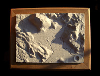
 We saw a few posts recently proposing to use the D-Shape outdoor printer to be modified for printing a lunar base. That’s an enticing and challenging possibility, but why not print the Moon on Earth while we await real lunar exploration? That’s exactly what space enthusiast Howard Fink did, as you can see in the image.
How did he do it? We’d like to say it was simple, but it doesn’t quite sound that way. According to LPOD:
He used a USGS digitized version of the old topographic map of the Apollo 15 area, which he read into Mathematica, converted into a 3D model with Maya, and printed with a rapid-prototyper or 3-D printer.
Apparently more DTMs (Digital Terrain Models) will be made available (thanks to the Japanese Kayuga and Lunar Reconnaissance Orbiters), so you should be able to do this for much of the lunar surface. Some Kayuga datasets are available here.
Via LPOD (Lunar Photo of the Day) and AstroPhoto