
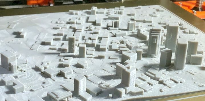
![It’s entirely possible to 3D print a cityscape without much effort [Source: Fabbaloo]](https://fabbaloo.com/wp-content/uploads/2020/05/image-asset_img_5eb09ff36eab9.jpg)
I’ve been playing with an interesting 3D mapping service, CADMAPPER.
I caught word of CADMAPPER through an interesting post by Prusa, but I’d like to tell the story here, too. This is a freemium-based service that can provide downloads of worldwide city maps on demand. They provide a number of notable city maps at no charge, but you can, for a small fee, download literally any city on Earth.
Here’s the interesting part: you can download the 3D representation of a city in addition to the traditional 2D map layer. This rough 3D shape can be 3D printed, although you must perform some CAD work on it first to make it truly printable.
![CADMAPPER section of NYC in 3D, viewed in Rhino3D [Source: Fabbaloo]](https://fabbaloo.com/wp-content/uploads/2020/05/image-asset_img_5eb09ff3c21f3.jpg)
CADMAPPER allows download in a couple of popular 3D formats, including Rhino3D (.3DM) and SketchUp (.SKP). Unfortunately, the file provided by CADMAPPER is essentially just the surface contour (including buildings). This means it’s basically a 2D shape that’s curved in 3D, and is unprintable as there are no solid portions. You will have to use your 3D CAD tools to add a “bottom” to the file and solidify it.
Prusa suggests using SketchUp for this purpose, although I would not normally recommend that tool for developing solid 3D models. However, it turns out that there is an extremely useful plugin for SketchUp, the Eneroth Terrain Volume extension. This tool automatically adds a volume underneath a surface, just what’s required for this problem.
Here you can see the problem: the ground surface is floating above the zero level.
![CADMAPPER’s 3D buildings are not immediately 3D printable due to missing terrain volume [Source: Fabbaloo]](https://fabbaloo.com/wp-content/uploads/2020/05/image-asset_img_5eb09ff41f25a.jpg)
But after using the extension, the ground is now solid. You definitely do not have to use this particular extension; the same function can be done in most CAD tools with a bit of ingenuity.
![After repair, the CADMAPPER 3D file is quite printable [Source: Fabbaloo]](https://fabbaloo.com/wp-content/uploads/2020/05/cadmapper-after_result_img_5eb09ff46f228.jpg)
The 3D model will also have to be rescaled, as CADMAPPER provides a download measured in meters. Thus your city section will almost certainly not fit in your 3D printer’s build volume – unless you have an extremely large, city-sized 3D printer. The file is easily scaled in utilities like MeshMixer.
After these changes you may find that, as is typical of models exported with SketchUp, there are STL problems. There will be inverted faces, some cracks and other common 3D model problems. I’d recommend not using MeshMixer’s “make solid” feature, as it will truly mess up the 3D model. The simplest approach is to just try slicing it for your 3D printer and see if the resulting GCODE is correct. Usually it will be so as the minor STL errors are usually properly fixed by the slicer. If not, consider a professional 3D model repair service like NetFabb or MakePrintable.
The file provided by CADMAPPER is actually components; each building is a separate item. This makes possible some interesting scenarios, where you might remove buildings from a city scene and replace them with buildings of your own design to simulate a proposed cityscape. Or perhaps you’d like to steal a building from elsewhere and put it in your town? Can I sell you a Brooklyn Bridge, perhaps?
![NYC skyline as generated by CADMAPPER [Source: Fabbaloo]](https://fabbaloo.com/wp-content/uploads/2020/05/cadmapper-nyc-detail_result_img_5eb09ff4b854e.jpg)
Note however, that the building detail can vary considerably.
In the NYC example above, the buildings seem to be quite well defined. Below is a section from the City of London, where you will see their crazily-shaped buildings are represented by simple blocks and cylinders. In some cases, buildings are missing; to add them, you must use a 3D CAD tool to raise up the ground to the proper building height.
![City of London skyscape generated by CADMAPPER is missing significant building detail [Source: Fabbaloo]](https://fabbaloo.com/wp-content/uploads/2020/05/cadmapper-london_result_img_5eb09ff502cee.jpg)
CADMAPPER provides this service in a freemium business model. That is, you are allowed to download small sections up to 1km square at no charge. If you wish to download larger sections you will be required to pay their reasonable rates. A six square kilometer section will cost you US$9, which is not bad at all.
The largest possible download is a rectangular area of up to 100sq km, at a cost of around US$63. I suppose cheapskates could painstakingly download 1km sq individual segments at no charge, but you’d have to somehow match all of them together. That would be a truly awful piece of 3D CAD work to do, as the boundaries would between segments would not be precisely cut.
CADMAPPER isn’t quite perfect, but it is a very useful system if you want to explore the idea of 3D printing or modifying cityscapes.
Via CADMAPPER


CoreXY is becoming a very popular approach for 3D printer motion systems, but is it the ultimate answer? We list the advantages and disadvantages.