
This week’s selection is ”Interactive maps for visually impaired” by physicist Sergei V. Bogdanov.
We’ve all used maps, although some of us should use them a bit more, but almost without exception these maps are visual. Printed on 2D paper or displayed on 2D monitors, this map imagery is inaccessible to those with visual impairment.
Bogdanov first observed the problem by visiting a school and seeing visually impaired students struggling with paper-embossed maps. He says:
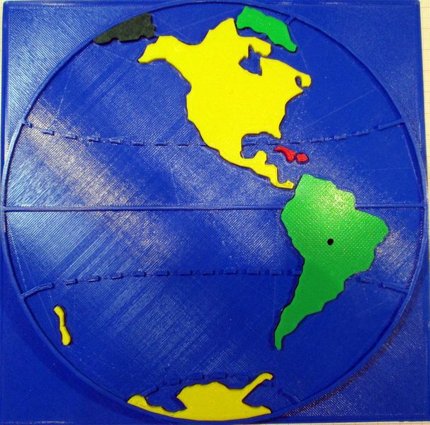
“We visited a boarding school for visually impaired children in Moscow Region, Russia. Visually impaired people can’t see geography maps and mathematical graphs, but they can sense a special type of it by fingers. We saw then the pupils study geography using poorly embossed paper maps. We decided to help to the students and all visually impaired.”
Bogdanov felt this barrier could be overcome with the use of 3D printing, where the “2D” could become “3D”. Although Bogdanov is in real life a physicist, he also dabbles in electronics and 3D printing.
The idea here is to reproduce the visual map elements with 3D equivalents that can be recognized by touch. That way anyone, including the visually impaired, can gain the information stored in the map.
The project has two stages. In the first stage structures were designed to represent the Earth, with pull-out continents. The tactile map also included geographic features like the Equator and major lines of latitude. A map reader can feel these lines and thus understand what they mean.
The second stage of the project is to incorporate electronics to enable playing of specific MP3 audio files when areas are touched. Then the student will be able to learn even more about the particular geographic feature in hand. And I mean literally “in hand”.
The project won an award at Hackaday, where you can find a full description of the project, including parts lists, files, code for the stage 2 elements and much more.
This is a wonderful way to leverage 3D printing in a way that may not have been fully explored. I suspect there are many other similar topics that could be transformed into tactile equivalents and thus open up much more knowledge for the visually impaired.
I have one question, however: The tactile maps, ironically, are produced in 2D projections. Could this accidentally lead to some Flat Earth misunderstandings?
Via Hackaday